Interconnection between mesoscale cloud systems and storms
Clouds play a major role in earth’s climate, yet present knowledge of the physics of monsoon clouds is inadequate. Individual clouds can be less than a kilometer in size, but clouds often aggregate in coherent structures that extend thousands of kilometers. Cloud clusters with scales of tens to hundreds of kilometers are called mesoscale cloud systems (MCS). Embedded within the mesoscale, there are groups of cumulonimbus clouds, or storms, with typical sizes of the order of 10 km (storm-scale). It is important to know how storms evolve within an MCS and how they influence its properties (e.g., area and precipitation).
A recent study by Sindhu and Bhat published in the Quarterly Journal of Royal Meteorological Society (2018) establishes the interconnection between MCS’s and storms over India during the 2013 monsoon season. The authors used Doppler Weather Radar (DWR) data from Hyderabad, Kolkata, Nagpur and Patiala (Figure 1a), where a major fraction of rain comes from summer monsoon low pressure systems and depressions (Figure 1b).
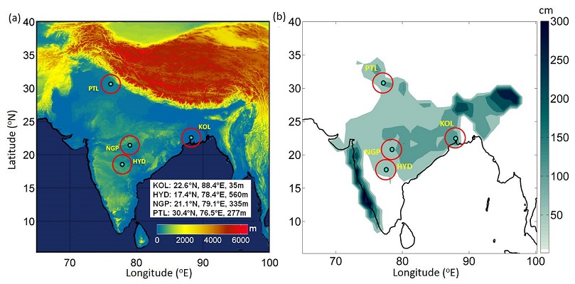
Figure 1 (a) Geo-locations of IMD’s S-band DWRs. Green dots show DWR locations and the outer circles depict radar range of 150 km. Background is USGS global 30 arc-second terrain elevation. DWR stations are: HYD-Hyderabad, KOL-Kolkata, NGP-Nagpur and PTL-Patiala. The inset shows latitude-longitude and elevation of the DWR stations. (b) Summer monsoon (June-September) average rainfall from the IMD 0.5°×0.5° gridded rainfall dataset for the period 1951 to 2003.
Monsoon MCS’s exhibit both leading-line/trailing stratiform (widespread layered) as well as disorganized structures as seen from radar reflectivity (a measure of hydrometeor concentration; Figure 2a). Intense rain rates are associated with storms; the number of storms varies from a few to more than 20, depending on geographic location and MCS life stage (Figure 2b and c). In the initial, developing phase, the MCS consists of a small number of storms (Figure 2c). As the MCS evolves in time to a mature phase, the number of storms increases rapidly and peaks; the decay phase of MCS is associated with a decrease in the number of storms. Remarkably,
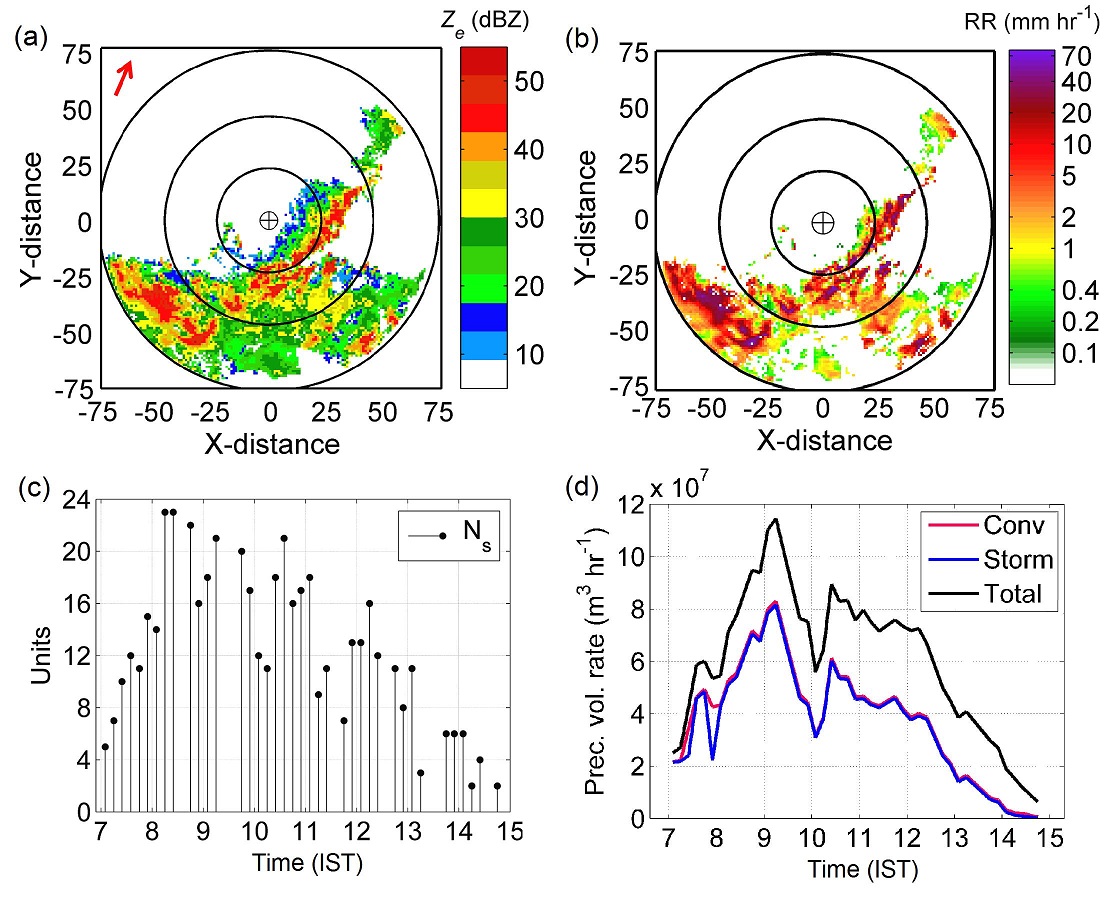
Figure 2 (a) Projection of the maximum Ze between 2 and 3 km altitudes at Kolkata. Time is 0900 IST, and units of x- and y- distances are respective number of pixels in the re-gridded data. Pixel size is 2 km×2 km. Arrow at the top left corner points in the direction of the gross movement of the cloud system (CS) around this time. (b) Rain rate (mm hr-1) derived from radar reflectivity (Ze) at 0904 IST. (c) Number of storms during CS lifetime at Kolkata. (d) Convective, storm and total precipitation volume rates in the CS.
90-97% of convective precipitation at any given time comes from storms (Figure 2d). To summarize, several cumulonimbus clouds in contiguous clusters constitutes a storm. Storms matter most for monsoon precipitation, making the storm-scale (of the order of 10 km) a very important scale within the hierarchy of tropical cloud systems. These results have implications for realistic representation of cumulus clouds in models (the “parametrization” problem), and for designing future satellites to measure precipitation.
 Reference
Sindhu K.D. and Bhat G.S. (2018): Characteristics of monsoonal precipitating cloud systems over the Indian subcontinent derived from weather radar data. Q. J. R. Meteorol. Soc; 1–19. https://doi.org/10.1002/qj.3328
Acknowledgement
The authors thank all those who supported the CTCZ programme including the Ministry of Earth Sciences, Govt. of India, IMD New Delhi and the CTCZ Data Centre at INCOIS, Hyderabad.
Author info: http://kapildevsindhu.weebly.com/


